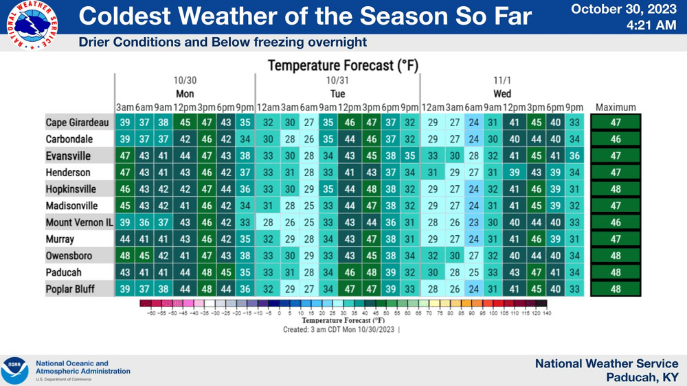
A cold front dropping into the area this week will dramatically decrease the mercury in Western Kentucky, resulting in the coldest temperatures experienced since mid-March.
Weather Edge forecaster David Powell said the drop began Monday morning.
There will be a Freeze Warning on Monday night, and it is likely that another one will be issued for Tuesday night.
Powell recommended implementing multiple layers of protection for trick-or-treaters over the next two evenings.
Powell emphasized that after Wednesday night, temperatures will remain above freezing overnight. He further advised that there are certain measures one should take to guarantee a trouble-free experience at home.
To protect your home during freezing weather, seal windows and doors, insulate pipes, maintain a consistent thermostat temperature, regularly check and maintain the heating system, and consider allowing faucets to drip to prevent pipes from freezing.
The cold front comes on the heels of record-setting rain on Sunday. The 3-4 inches that fell was the most for October, breaking the old mark set in 1970.
The Kentucky Mesonet recorded 3.71 inches of rain in Christian from Saturday until 6:00 Monday morning. During the same period, Trigg County received 3.73 inches of rain. Todd County checked in with 1.4 inches. And Caldwell County’s mesonet site logged 3.11 inches.
Kerry Fowler reported 5 inches of rain on Princeton Road just north of Cadiz. Joe Nichols shared he received 5.43 inches of rain at Seven Springs Farms in Wallonia, and Manuel Brown said he got 4.70 on Main Street in Cadiz.