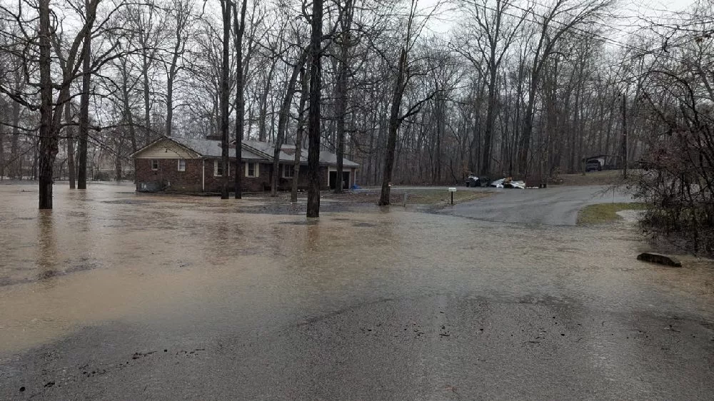
Heavy rain has led to widespread flooding across the region, causing significant travel disruptions and prompting emergency management officials to urge residents to stay home as conditions are expected to deteriorate further with more rain and thunderstorms forecasted for Saturday afternoon.
List of roads in KYTC District 1 impacted by high water as of 5:00 PM Saturday:
Ballard County
KY 310/Turner Landing Road is open with high water at the 1 MM. This is between KY 358 and U.S. 60 – NEW
KY 358 is open with high water between the 6-9 MM in the city of LaCenter. – NEW
KY 1837/Blandville Road is open with high water between the 8-9 MM. – NEW
KY 2532/County Line Road is open with high water at the 4 MM west of the Ballard-McCracken County Line. – NEW
KY 62 is open with high water between the 0-2 MM in the community of Lovelaceville. – NEW
KY 802/ La Center Road is open with high water between the 9-10 MM at the intersection of KY 1290. – NEW
KY 121/Mayfield Road is open with high water between the 1-4 MM, south of Blandville near the Ballard-Carlisle County Line. – NEW
Calloway County
KY 299/Butterworth Road is open with high water at the 0.7 MM. This is just north of KY 94 W.
Carlisle County
KY 1820 is closed with high water between the 1-3 MM (Wilson Creek). This starts near the intersection of KY 1628.
KY 1628 is closed with high water between the 3-4 MM (Wilson Creek). This is between KY 1820 and U.S. 62.
U.S. 62 is closed with high water at the 4 MM near the West Fork Creek Bottoms.
KY 80 W is closed with high water between the 2-3 MM in the city of Arlington.
Fulton County
KY 94 (Lower Bottoms) is closed with high water between 9.1 MM (Parker Lane) to 10.9 MM (1099 Bypass).
KY 94 (Willingham Bottoms) is closed with high water between 23.44 MM (KY 781) and 25.5 MM (Jeffress Road).
KY 1128 is open with high water at the 3.85 MM (Mud Creek).
Graves County
KY 1283 is closed with high water between the 2.9-3.2 MM from Frazier Road to KY 58.
U.S. 45 S is closed with high water between the 0-2 MM in the Water Valley Community.
KY 58 W is closed with high water between the 0-1 MM just east of the Hickman-Graves County Line near the KY 1283 intersection.
KY 408 is closed with high water between the 9.2-10 MM. This is between Ethel Road and McCracken County Road, approx. 1 mile east of U.S. 45.
Hickman County
KY 123 is closed with high water between the 14-16 MM in the Hailwell Corner area.
KY 1283 is closed with high water between the 1-2 MM near the Hickman-Graves County Line.
U.S. 51 S (Greenway Bottoms) is closed with high water between the 2-3 MM near the Hickman-Fulton County Line. This is near KY 1529.
KY 58 W is closed with high water between the 7 and 8 MM in the Cane Creek area. This is at the intersection of 1475.
U.S. 51 N is closed with high water between the 9-10 MM. This is between KY 1728 and KY 1540.
U.S. 51 N is closed with high water between the 11-13 MM, near the intersection of KY 1301.
KY 307 N (Beulah Bottoms) is closed with high water between the 13-14 MM. This is between KY 703 and KY 1748.
KY 2206 is closed with high water between the 0-1 MM. This is between KY 703 E and Rebiel Road.
KY 1529 is closed with high water between the 4-6 MM, intersecting at U.S. 51 S. This is between KY 1825 and KY 2209.
Lyon County
KY 1943 is closed with high water between the 3-4 MM near Skinframe Creek Bridge.
KY 293 is open with high water near the 2.5 MM at the intersection of KY 730.
KY 903 is open with high water at the 1.2 MM. This is between KY 730 E and KY 1272.
KY 3305 is open with high water between 0-2 MM. This is between KY 93 and U.S. 62 E.
Marshall County
KY 1462/Benton-Birmingham Road is closed with high water between 0-1.3 MM. This is between KY 408/E. 12th Street and KY 1477/Benton Briensburg Road.
KY 1311/Slickback Road is closed with high water between the 3-5MM.
KY 1949/Wadesboro Road is closed with high water at the 7.4mm at the I-69 Tunnel.
McCracken County
KY 1255/Bonds Road is closed with high water between the 0.0 MM (KY 348/Hardmoney Road) and the 2.3 MM (KY 450/Oaks).
KY 1014/Houser Road is closed with high water at 3.7 MM at the intersection of KY 994/Old Mayfield Road.
Trigg County
KY 1507/Barefield Road is closed with high water at the 1.0 MM. This is between U.S. 68/Hopkinsville Road and KY 958/Montgomery Church Road.
KY 128 is closed with high water between the 0.0 MM at U.S. 62 and the 1.0 MM, just past the intersection of Dunkerson Road.
KY 525/New Hope Road is closed with high water at the 4 MM. This is near the intersection of Prather Road.
List of roads in KYTC District 2 impacted by high water as of 6:00 PM Saturday:
According to the Kentucky Transportation Cabinet, motorists should use extreme caution when traveling on Interstate 24 westbound between the 48 and 49 MM in Lyon County. Local highway crews say this area is in a curve and has water flowing across both lanes. Three crashes have occurred in this location today due heavy rain and hydroplaning.
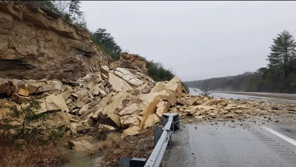
Also, the right lane of northbound Interstate 69 is blocked by a rockslide at the 87 MM near the Caldwell-Hopkins County Line in KYTC District 2. The left lane of the roadway is open. Duration of the blockage is currently unknown.
Caldwell County
KY 126 is blocked by high water at the 1 mile point near Trigg County
KY 128 open with high water at 3.2 mile point
Christian County
U.S. 41 open with high water between the 2.6-2.7 mile points
U.S. 41A open with high water between the 15.2-15.9 mile points (CLEAR)
KY 109 open with high water between the 10.9-11.3 mile points
KY 115 open with high water between the 0.8-1.0 mile points
KY 117 open with high water between the 7.0-11.5 mile points
KY 124 blocked by high water between 1-2 mile points
KY 164 open with high water between the 3-4 mile points
KY 272 open with high water between the 10.3-10.6 mile points
KY 287 open with high water between their 2.2-3.1 mile points
KY 345 blocked with high water between the 0-4 and 9.2-9.5 mile points
KY 380 open with high water between the 1.8-2 mile points (CLEAR)
KY 400 open with high water between their 0-1.3 mile points
KY 695 blocked between the 2-3.5 mile points
KY 695 open with high water between the 12.1-12.4 and 12.7-12.8 mile points
KY 1007blocked by high water between 0.8-1.4 mile points
KY 1453 open with high water between 0-2 mile points
KY 1663 blocked by high water between the 0-2.1 mile points
KY 3186 open with high water between the 0.4-0.8 mile points
Daviess County
KY 81 open with high water between the 2.4-3.6 mile points (NEW)
KY 142 open with high water between the 4.4-5.9 mile points
KY 140 open with high water between 1-3 mile points (NEW)
KY 298 blocked by high water between the 2-3 mile points
KY 762 blocked by high water between the 0-1 mile
KY 1207 open with high water between the 1.4-5,4 mile point (NEW)
KY 2127 open with high water between the 0-1.3 mile point (NEW)
Henderson County
KY 1557 is blocked by high water between the 2-3 mile points (NEW)
Hopkins County
KY 254 open with high water between their 1-2 mile points
KY 502 open with high water between the 1-4 mile points
KY 1033 open with high water at the 4 mile points
KY 2881 open with high water between the 0-1 mile points
KY 3059 open with high water between 1-2 mile points
Muhlenberg County
KY 181 open with high water between their 12.7-12.8 mile points
KY 949 open with high water between the 5-6 mile points
KY 1379 blocked by high water between the 0-2 mile points
KY 2107 is open with high water between their 1-2 mile points
KY 2270 open with high water between the 6-9 mile points
KY 2533 open with high water between the 0-1 mile points
KY 2590 open with high water between the 0-4 mile points
Ohio County
U.S 62 open with high water between their 5-6 mile points (NEW)
U.S. 62 open with high water between the 8-9 mile points
U.S. 62 open with high water between the 15-17 mile points
KY 69 is open with high water between the 18-19 mile points (NEW)
KY 919 is open with high water between the 3-4 mile points (NEW)
KY 2670 open with high water between the 0-1 mile points
KY 2718 open with high water between their 3-4.5 mile points
Webster County
KY 138 blocked by high water between the 10.6-10.7 mile points
KY 270 blocked by high water between the 6.8-8.3 mile points
Be aware of areas that frequently flood and proceed with caution
Turn around, don’t drown.
At 2:15 p.m. Saturday, Caldwell County Emergency Management Director Joey McCaslin informed WPKY’s News Edge that the Kentucky Transportation Cabinet is setting up a one-lane closure on I-69 northbound between the 86-87 mile markers to bring in a track hoe to remove some more debris from the rockslide that’s next to the road.
At 11:30 Saturday morning, Christian County Emergency Management Director Randy Graham said there were several roads in the county impacted by high water.
He encouraged everyone to stay home, if possible, as conditions will worsen throughout the day with additional rain and thunderstorms this afternoon.
At 11:30 AM, Hopkins County Emergency Management Director Nick Bailey reported they were monitoring the rising water.
He said the Kentucky Transportation Cabinet was reporting two roads impacted by the high water in Hopkins County at that time.