So where is the fall weather? Afterall, it is getting to be late September and we are still dealing with warm highs in the upper 80’s and uncomfortable humidity. We have been getting brief shots of cool air but they just don’t last long.
As I explained in my previous blog post, changes are coming. But not until around September 26th give or take a day or two. High temperatures will climb to above-average levels during multiple days this week and maybe next weekend in many areas. Normal highs are in the upper 70’s, but this week’s temperatures will hit the upper 80’s. The warmth will continue past the first official day of Autumn, which is Thursday, Sept. 22. 
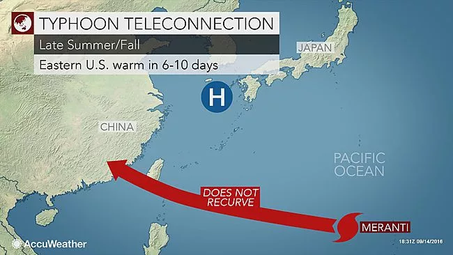
Believe it or not, the warm surge during the middle and latter part of this week will be largely fueled by the path of Meranti, a typhoon which blasted Taiwan on Wednesday and made landfall in China early Thursday, local time. Meranti moved inland over China this past week. When tropical storms and typhoons fail to re-curve to the east and away from Asia, the corresponding weather pattern across the Pacific and North America favors a buildup of warmth in the eastern part of the U.S. six to 10 days later. The path of Meranti, while a typhoon and tropical storm, correlates to the warmth forecast we have for the middle and latter part of this coming week. Conversely, when tropical storms and typhoons take the curved path and avoid hitting mainland Asia, the weather pattern thousands of miles farther to the east tends to deliver much cooler weather in the eastern U.S. six to 10 days later.
In short, the way a tropical cyclone curves northeast of Japan amplifies the jet stream over the Pacific Ocean and North America. The jet stream is a zone of high speed winds at high levels of the atmosphere that often marks the path weather systems will take. The jet stream typically marks the boundary between cool air to its north and warm air to its south. One such typhoon, Malakas, is projected to curve away from Asia early this week, which would set into motion much cooler air in the eastern U.S. just prior to the end of September. The tracks of western Pacific typhoons are a different type of teleconnection, and they can give us important clues about how weather patterns will change over North America in the following 7-10 days. Specifically, a recurving typhoon like Malakas is often a sure sign of a deep trough developing over North America the next week. That translates to much cooler, fall weather for western Kentucky.
This is not a direct cause-and-effect relationship – the typhoon doesn’t cause the North American trough, but there is a linkage. The typhoon pumps heat into the ridge commonly found to the east of Japan. This in turn causes a trough to dig in over the Bering Sea, which builds a ridge over the Gulf of Alaska. Finally, a trough begins to dig in over the central US, which builds a ridge east of the Appalachians. You can think of it as a domino effect, or perhaps more precisely, like kids on a playground making waves in a jump rope. Although in this case the jump rope is the jet stream, and the kid tugging on the end is the typhoon.
What makes this relationship particularly useful for forecasters, is that the track the typhoon takes can help us forecast the position of the trough 7-10 days later. It tells us not only that there will be a trough, but where it is likely to be. If the typhoon tracks east of Japan, the trough is often found in eastern North America. A typhoon recurving further west, off Taiwan suggests a trough over western and central North America, with ridging and warm weather developing near the Great Lakes. One thing is almost sure, summer is about to be at an end. Feel free to leave comments and be sure to hit the “Like” button at the bottom of this post.


