UPDATED STORY
The National Weather Service in Paducah has issued a tornado watch for most of western Kentucky to include the counties of Caldwell, Calloway, Hopkins, Lyon, Marshall and Trigg Counties until 11 pm tonight.
The Storm Prediction Center has upgraded a part of western Kentucky, from Trigg County westward into a moderate threat category with the rest of the area in an enhanced risk for severe weather.
Meteorologist Derrick Snyder says the moderate risk for severe storms is uncommon, especially in the winter.
Snyder says the weather should move into the lakes area around 7 o’clock and with it, bring severe elements that could be dangerous.
Snyder went on to say that the storm could produce several rounds of weather throughout the night and early morning hours.
According to National Weather Service records dating back to 1960, Caldwell, Lyon, and Christian counties have never recorded a December tornado. Todd County’s first December tornadoes were earlier this week, and Trigg County recorded one on New Year’s Eve in 2018. Snyder says severe weather like this is uncommon in December and makes their forecasting job harder because of the different characteristics of the storms.
Earlier today, the National Weather Service said the environment is definitely prime for a significant event with the combination of sheer and instability very favorable for a significant severe thunderstorm event.
If severe weather breaks out, we’ll break in and provide updates of any severe thunderstorm warnings and tornado warnings in our area.
ORIGINAL STORY
Meteorologists with the National Weather Service say there is the potential for damaging winds and tornadoes Friday evening into Saturday morning in western Kentucky.
The Storm Prediction Center has upgraded a part of western Kentucky, from Trigg County westward into a moderate threat category with the rest of the area in an enhanced risk for severe weather.
Meteorologist Sean Poulos says the environment is set up to produce explosive thunderstorm development that could produce damaging winds and tornadoes, but they are unsure of the timing of the severe weather event due to a cap.
click to download audioHe adds the enhanced risk is a Level 3 out of 5 for severe weather with the primary threat of damaging winds and tornados.
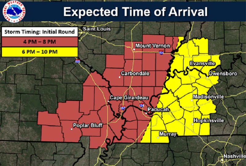
As far as the timing of the storms, Poulos says there is a chance for some discrete supercells to develop when the cap erodes Friday afternoon with more than one round of severe storms developing later in the evening and progressing across the area. He says the potential for severe weather across western Kentucky exists from anywhere between 6:00 p.m. Friday to 4:00 Saturday morning.
click to download audioAccording to Poulos, they are still unsure of the timing when storms will start to fire up Friday evening but he says the environment is definitely prime for a significant event with the combination of sheer and instability very favorable for a significant severe thunderstorm event.
Poulos also noted this is the second severe weather event in a week which he added was a little unusual in December.
If severe weather breaks out, we’ll break in and provide updates of any severe thunderstorm warnings and tornado warnings in our area.